MT. ACONCAGUA: Dec 2015 – Jan 2016
I am back from my latest trip and here is a quick summary:
Aconcagua was very different from my Alaska trip. In Alaska, the plane lands you on the glacier with all your gear and then it is up to you and your teammates to take everything with you as you move up the mountain. You do a series of climbs to cache gear and then back down to sleep for the night before moving the whole camp higher and repeating the process. Most days you have a full backpack and are pulling a sled with another 50+ lbs of gear.
On Aconcagua, it is partly a trekking expedition along with climbing higher on the mountain like we did in Alaska. We started in the town of Penitentes, Argentina at a hotel. There we separated our gear into 3 piles: 1) items that would not be needed until base camp – these items would be transported by mules directly to base camp, 2) items that we needed the next 3 days but would be transported by mules to us each day, and 3) items that we carried with us.
The first 3 days of the hike were very warm, mostly in the 70’s-80’s. The first two days were in shorts and tee shirts carrying a day pack with snacks and an extra layer of clothing. The third day was cooler but still sunny and warm although breezier. We still had our day packs until we reached base camp.
From base camp, we adopted a more traditional schedule of carrying/caching gear higher and returning lower to sleep and rest. Then, moving everything up to higher Camps. Ultimately we continued this process to Camp 2 and Camp 3 which is main camp before the summit.
My goal going into this was obviously the summit first, secondly I wanted to get over 20,000 feet (6,096 meters) and my last goal was to at least reach high camp (approx 19,600+ feet or 6,000 meters).
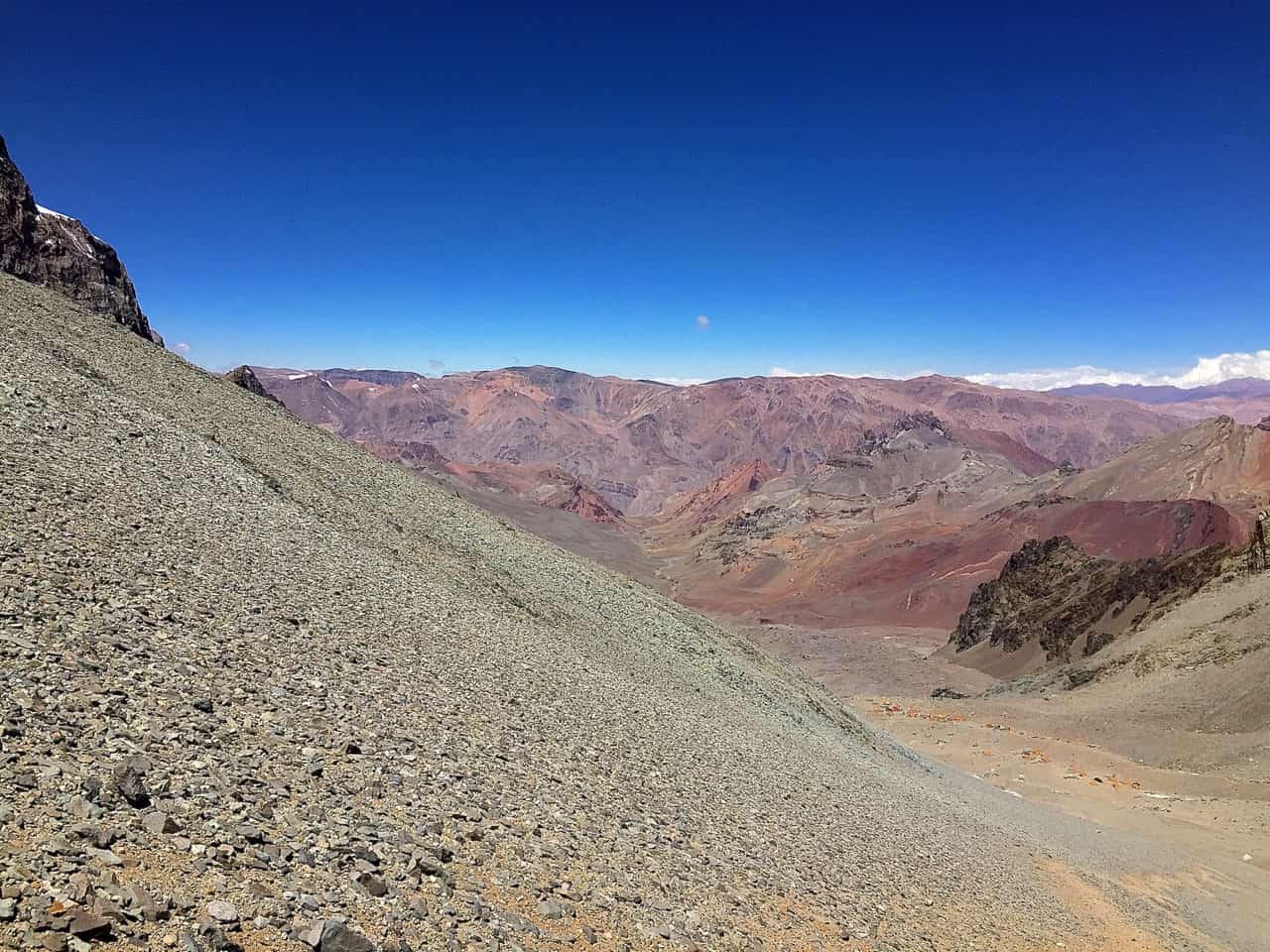
Unfortunately I was unable to summit. However, I did make it somewhere between 21,400 (6,522 meters) and 22,200 feet (6,766 meters). Although I did not make the summit, I was still very happy with how I did. The views are pretty amazing that high up!
The second picture below was taken on the summit day after sunrise. I believe I was somewhere around 21,000+ feet in altitude when I took this photo.
If you compare the two pictures you can see that the first one we are just above most of the surrounding mountains whereas the second photo is significantly higher than everything around. Both photos were taken in roughly the same direction.
If you compare the two pictures you can see that the first one we are just above most of the surrounding mountains whereas the second photo is significantly higher than everything around. Both photos were taken in roughly the same direction.


Dec 29 – We met around 10am with all our gear and then waited for the shuttle driver and the climbing permits to be worked out. We drove 2-2.5 hours and stopped to have a huge lunch around 2pm. I have come to the conclusion that the reason the Argentinians are not in great shape is because they eat such huge portions.


Another hour of driving brought us to Penitentes. I am not sure if this is the town name or the name of the ski area/hotel we stopped at.
Penitentes ski area - Supposedly it never opened last winter. Penitentes is around 8,000 feet (2,438 meters). After organizing the gear, we took a short hike 600-700 feet up the ski slope to help acclimatize ourselves.
Here we finalized our gear and separated it into four piles.
The first pile was gear that we did not need until we reached base camp. This was most of the colder weather gear, crampons, climbing boots, some snacks, etc. This gear would be loaded onto mules and we would see it 3-4 days later.
The second pile was stuff we would carry in a daypack the first three days. Mostly snacks, water and an extra layer of clothing.
The third pile was stuff that was going on mules but that would be be going with us each day for the first three days until we reached base camp. This would be sleeping bags, tents, eating utensils, extra clothing, etc. We did not need to carry this stuff and when we stopped to camp, the mules would drop it off for us.
The fourth pile was stuff we did not need on the mountain at all and would stay in Penitentes until we returned. This would be airline tickets, clean town clothes, dirty clothes, etc.


Dec 30 – D-day is here. It’s time to hike and climb. We all piled into a LandRover and drove 4-5 miles to the park entrance. It wasn’t much except a couple of shacks where the Rangers checked the climbing permits. The first two days of hiking are almost directly north along a river. Mostly small ups and downs of 50-150 feet.


We took about 4:45 hours to hike 7 miles to Papa de Lenas (9,330 ft/2,843 meters) and gained about 1330’ of elevation. This would be our first night of camping. It was a very warm day, probably in the low 80’s and very sunny. But there was a nice breeze and the air is very dry so it was comfortable. At camp we had to wait an hour or so for the mules to show up with our gear for the night. We then set up tents and had a spaghetti dinner. The guides surprised us with fresh watermelon for a snack while we waited.


Dec 31 – We were up around 6am, had breakfast, broke camp and were hiking around 8:15am. In the very center of the picture you may be able to make out a couple small buildings at the foot of the mountains. That is where we are going for our second night of camping. Another real easy hike of around 9 miles to Casa de Piedra (10,665 ft/3,251 meters). We gained another 1,335’ of elevation. It was very windy most of the hike with gusts 30-40 mph. Because of the wind, setting up the tents was a pain and we had to secure them pretty well to rocks. After dinner we were off to bed around 8pm.


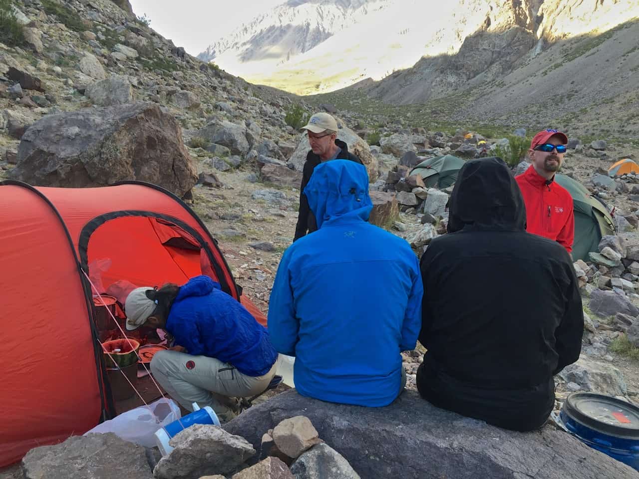
Jan 1 – Happy belated New Year to all. Today is a big day, we are heading to base camp. We were up around 5am with cereal and PB&J for breakfast. We broke camp, left our gear for the mules and started hiking around 6:50am. We had to cross 3 small streams about 200 yards out of camp. The streams are usually a lot higher, up to mid-thigh we were told. Sometimes they are flowing too high and strong and they have to rent mules to get us across. This year there is very little water flowing. It was probably just up to our lower calfs. However, the water was absolutely frigid and we were all happy to get our socks and boots back on. It was another pretty easy day of hiking with lots of sun and a nice breeze. It was cooler with the elevation but pants and a windbreaker was all we really needed. We gained about 3,335 ft/1,016 meters over 7 miles. The guides had us doing a nice slow pace and we made it to Plaza de Argentina (14,000 ft/4,267 meters) in the early afternoon. We set up tents and relaxed for the afternoon. The guides we used are partnered with a local guide company called Grajales. Grajales has some common areas that we use and provide some of the meals at base camp for us. That night we had a very good lasagna for dinner.
Jan 2 – We got to sleep in this morning as this is a rest day for us to help with the acclimatization process. We had breakfast at 9am, French Toast with bacon and cereal. We also discussed what to expect the next few days. Tomorrow is a “carry” day where we will take gear and food to Camp 1 to cache it before returning back to base camp for the night. We received our gear that was sent directly to base camp from Penitentes. A few of us went for a walk around camp and started sorting through all our gear. After that we relaxed, napped and read books.
As a side note, the meals that Grajales are providing have wildly exceeded my expectations. In fact, I didn’t even realize we were going to get meals like this. I just assumed we would be cooking and eating near our tents every day.
As a side note, the meals that Grajales are providing have wildly exceeded my expectations. In fact, I didn’t even realize we were going to get meals like this. I just assumed we would be cooking and eating near our tents every day.


Base camp. This photo was taken coming down from Camp 1 and shows how big an operation this base camp is. The complex of 10-12 white and yellow tents to the right are the Grajales guides our US guides teamed up with. You will see red and white tents to the left and other groupings of big tents throughout base camp, they are all local guide services that other companies usually team with. They usually provide a number of meals, water (you still have to treat it), bathrooms (OK, really phone booths with holes in the floor or occasionally a seat), internet service and beer and cokes (for a really hefty price). I had a 16 ounce Coke for $5.
Jan 3 – Today is a “carry” day and we are going to take gear and food up to Camp 1 to cache until we move everything out of base camp. This includes some of the warmer clothing, crampons, food/snacks etc. that we do not need until higher on the mountain. We have pretty heavy packs today – probably 50+ lbs each. The hike was tough as the trail is really rocky and there is a lot of scree which slows you down a lot. Today we are gaining roughly 2,400 ft/731 meters over 2 miles. We started hiking around 9:15am and reached Camp 1 about 5 hours later. The hike down only took around 2 hours. It was a perfect hiking day, clear skies, fairly warm with a light breeze. My knee was sore so I used a knee brace Guide Richard had on the way down and wore it the rest of the trip. Had an excellent chicken and rice dinner that night.


Jan 4 – This is rest day to help recover from yesterday and provide some additional acclimatization. We had a nice breakfast omelet with bacon and leftover steak and onions in it. We took a relaxing two hour walk near camp to stretch out our legs. Around 3pm we had lunch of tortillas with cheese and tuna in them. Then we mostly relaxed and cleaned our clothes and camp as best we could. We also created two piles of gear – the first pile was gear that we no longer needed that could go to the hotel in Penitentes and the second pile was gear that would be taken to another base camp on the other side of the mountain called Plaza de Mulas. This was our trekking boots, shorts, tee shirts, etc. Mostly stuff we would use to get down the mountain once we reached the other base camp. The weather was very nice again, temps in the 50’s, very sunny with minimal clouds.
The guides also discussed hiring some porters to help get gear to Camp 1. After a short discussion, we were all for that and hired 3 porters. They mostly carried some of the group gear such as tents, cooking gear, food, etc. As a bonus, they would have the tents set up when we arrived at Camp 1 saving us 1-2 hours of work. The porters carry a maximum of 44 lbs/20 kilograms each but the end result is that instead of us each carrying 80+ lbs on move day, we would have 40-50 lbs each.
With the good food I mentioned, some people were wondering how much weight I gained on this trip…I actually weighed in at 205 lbs/93.2 kg and at the end of the trip I was 193 lbs/87.4 kg. I lost about 12 lbs in 16 days. If it wasn’t for those good meals, I might have wasted away right on the mountain…
Our route out of base camp will go directly behind the yellow and white Grajales tents in the middle of the picture. We will be near the rock mass to the left and start up the valley pretty much to where you see the point of the “V” in the middle of the picture. Once we get up to that area, things become somewhat flatter with more small rolling hills.
In these next 2 pictures, we have gained some elevation out of base camp and can see our goal. If you look at the snow field that is coming in from the right hand side of the pictures and follow it all the way to the middle of the picture where it comes to a sharp point at the top of a steep face, Camp 1 is located just at the top of that plateau. It’s deceptive from the distance but that last 200-300 foot climb is steep. The last 50-75 feet before you reach the plateau is really steep and full of scree making climbing very slow. A lot of time if you don’t step carefully you slip back a step or two.


In these photos, you can see where we have come from. This photo was taken from Camp 1 near the edge of the steep face we climbed up. Just left of center in the picture you can see the valley we followed from Casa de Piedra (where we camped the second night on the trail) to Base Camp. If you follow the dark brown rocks from the right side of the picture all the way to their left edge, then go to the very bottom of that rock face, Base Camp is located a few hundred feet below that in a relatively flat area that can’t be seen in this photo.


Jan 5 – Up at 6:30am to break camp. Breakfast at 8:00am and we started hiking around 9:15am. This was a tough trail with over 2,400 ft/731 meters gained in 2 miles. Thankfully we have 3 porters that are carrying a total of 130+ lbs/60kg of weight that we don’t have to carry. It’s another sunny, breezy day. Our progress was OK but Larry was pretty sick and had to stop a lot. We made it to Camp 1 around 2:15pm. The tents were set up so we just piled in and relaxed for a couple hours with occasional bursts of energy to unpack our gear. Dinner was some pasta mess that the guides cooked around 6:30pm. It tasted good but I tend to lose my appetite at higher elevations and don’t always eat as much as I should. Around 7pm the sun started dropping behind the ridge and it started cooling off so we jumped into our tents for the night.
Jan 6 – I had my best night of sleep so far and felt pretty good in the morning. I read a book in the AM for a while and we all started getting up around 9am for breakfast. It was a windy night and windy all morning so far. Maybe mid-40’s temps and steady 20 mph winds with gusts to 35 mph. We had oatmeal in an empty tent site near our camp behind a rock wall to cut the wind. I then worked on the rock wall around our five gallon bucket (toilet) for an hour so we could have a small bit of privacy. Then we mostly relaxed in the afternoon.


Jan 7 – I couldn’t sleep much last night. Probably because I relaxed and slept so much during the day. I might have got 3 hours total sleep. We got up late for breakfast because we weren’t sure what the plan was for the day. Eric was still not feeling well and decided to leave the expedition. His buddy Kim hurt his back and also decided to leave. Their friend Larry called home and after consulting with his wife, also decided to leave. We took a couple hours to tear down 2 tents and move the remaining 3 people into the larger, 4-man tent. Guide Richard then took Kim, Larry and Eric and a lot of extra food and gear that was no longer needed to base camp. Guide Aidan, Doug, Bob and I then loaded up with gear and food to cache it at the top of the Col leading to camp 2. We started hiking around 1:30pm and reached the cache site around 4:30pm.
It was a very windy day. We probably gained around 1,000 ft/305 meters and our guide Aidan (who is also a pilot) estimated winds and gusts where 60-70 mph where we cached our stuff. We immediately started down to get out of the wind. The wind was expected to be bad the next couple of days so we are not sure if we will move up or stay at camp 1 for the duration. We also have to wait for Guide Richard to get back from base camp either tonight or tomorrow. It was tough to see Larry, Kim and Eric leave. They were very good hikers and climbers and enjoyable company.


This picture is looking down from where we cached gear. At the bottom of the hill in the middle of the picture you can just make out tents at camp 1. In addition, in the distance you can see the valley we hiked on day 3 to get to base camp.

Here is another picture looking back down towards camp 1. For those wanting to know what scree is, just look at the gravel and rocks on the left side of the picture. You can also see the trail in the lower right corner of the picture.


Jan 8 – We slept in since the winds were really high. Gusts at camp 1 were in the 50-60 mph range. So we had some cereal for breakfast and relaxed most of the day. Aroud 6pm the winds finally died down to nothing, zero clouds and very nice temps. In bed early since we are moving everything to camp 2 tomorrow. I have a couple videos that will give you an idea of the winds you can watch on my video page..


Jan 9 – Up with breakfast at 6am. Perfectly calm night with no wind finally. We packed up camp and started climbing about 8:20am. Fantastic weather conditions – mild and no clouds but my pack was probably 60-70 pounds (27-32 kg). Guide Richard and Bob went ahead with the tents to try and get 2 good tent sites at camp 2. Guide Aidan, myself and Doug took a slower pace. We made it to camp 2 (18,000 feet/5,486 meters) around 12:45pm. The tents were set already set up which was nice. The scenery is gorgeous and the views are fantastic the higher you go. The mountains in the distance have a lot of muted tans, browns and rust colors and large patches of snow. Mountains closer have more grays and blacks with lots of gravely scree. We have the afternoon to relax, take photos and enjoy the views. Tomorrow we will go back to the Aubergine Col to back-carry all the gear we cached a couple days ago. Overall the move to camp 2 was a 1,600 foot (487 meters) elevation gain. Camp 2 is also known as Chopper Camp as well as Guanacos III Camp.
Jan 10 – Up at 7:30am and had some cereal for breakfast. We grabbed our empty packs and hiked back to our cached gear and picked it up. It took 30 minutes to get there as it was mostly downhill or flat. The hike back up took an hour and a half or so. We then had another breakfast of pancakes. After that we spent time going through all the food and gear. Richard, Aidan and Bob then took stuff to cache at camp 3 which is at 19,600 feet (5,974 meters). Doug and I did the dishes and I walked around camp to give away a lot of excess food since we lost 3 people. The rest of the afternoon was free for relaxing, reviewing personal gear, writing these notes, etc. The weather was great again – mild temps, lots of sun and a light breeze. The glacier behind us melts during the warm days and a stream splits the camp in two. At night, it freezes and stops flowing completely until it warms up enough the next day to start again. Tomorrow the plan is to move everything to camp 3 so we will have very heavy packs again!
Looking back, you can just make out the path we followed. In the middle of the picture to the very right hand side, you can make out another group of people on the trail heading towards us.


Jan 11 – After a partial rest day yesterday, we are moving everything to Camp 3. We had heavy packs and left around 9:30am and arrived at Camp 3 around 2:50pm. The first 45-60 minutes out of camp were very steep but after that the trail was pretty good although the altitude wipes you out quicker. Aidan and Bob went ahead and tents were set up again when we got there. This is a huge timesaver. The latest on the weather is that tomorrow will be a great day to try and summit and the day after not so nice. The guides both thought I definitely had it to make a summit attempt without a rest day. So, Bob and I and the two guides will be giving it a try tomorrow. Doug is completely wiped out and he is going to take a rest day.


The picture below looking off the West side of the camp is where we will hike out to the base camp on the other side of the mountain on our way out. If you look closely you can just see the hint of a trial in the lower middle of the picture. You can also see a steel cable. The initial descent is very steep for the first 100 feet and the cable is there to assist you. In addition, climbing down all the scree after that is very difficult with fully loaded packs.


Jan 12 – We were up around 4am. It’s pretty cold although I have no idea what the temperature is. Probably down in the single-digits maybe into the mid-teens. We started climbing around 5am in the dark using our headlamps. After about 30 minutes guide Richard and Bob took off and Guide Aidan and I took a slower pace (one I could handle!). Around 1-1.5 hours the sun started to come up a little. Around this time during a break I told Aidan that I didn’t feel like the summit was going to happen but I wanted to get over 20K feet at least. He said we would take it slow and enjoy the day which was beautiful – minimal clouds, low breezes and ultimately, lots of sun. I took the lead so I could move at a steady pace. Aidan was really good about setting some short goals like “There is a great view 300-400 feet up and it should take only an our or so to get there.”, or, “The Independencia Hut is only 500 feet ahead.” So, after each break I decided to move on to these interim goals. Since I was leading I was able to go at my pace and we took a number of breaks.
At the Independencia Hut (around 21,400 feet/6,523 meters) we took a long break and I seriously contemplated stopping for the day. However, Aidan again convinced me to move on and I concurred. At this point we had to put on crampons to get over a small glacier field – maybe a total of 150 feet elevation. Once we got over that, there was a very long traverse along the West Face of Aconcagua, ultimately coming to the Canaleta (a couloir) which has a climb to the summit. About 25% of the way across this traverse we took a break. It was here that I decided that I could not go on. Technically I could go on but realistically, I was looking at 3+ hours ahead of us for only a thousand feet and I was out of gas. Aidan thought I was at around 21,100 feet but since the Independencia Hut is actually at 21,400 feet I am estimating that we were actually closer to 21,750 feet/6,629 meters. I haven’t had time to coordinate with the guides on this so I ended up somewhere above 21,000 feet and probably closer to 22,000 feet. So, after some discussion, we started down. The trip down was much quicker and we reached Camp 3 around 12:30 – 1pm.
The guides were great about trying to get me to the summit. They offered to have one guide take the other 2 climbers down to Base Camp and let me try to summit again the next day or even take a rest day and try the day after. I was pretty tired and told them I doubted I would try but I would also think about a bit. Later in the afternoon I came to the conclusion that I was wiped out and would not make another attempt. The items that contributed to this were probably not enough good sleep for a number of days (it’s tough to sleep good at altitude when your breathing is labored and you are up 2-4 times a night to use the pee bottle), not eating enough in general (I lose my appetite at higher altitudes and I was stuck with buying a lot of snacks that I was unfamiliar with and did not really like that much), and not taking a rest day at Camp 3 before trying to summit. In any case, I decided to move down although the temptation of having a personal guide to make another summit attempt was very high!

These photos were taken at the Independencia Hut (21,400 feet) around 8:55am. The hut is extremely small, you could maybe put 2-3 people inside it and part of the roof is missing. It can be used as an emergency shelter but at that altitude, it only provides a little bit of relief from the elements.
This photo was also taken at the Hut looking up. You can see a couple groups heading out and the small glacier area that continues up to the left that we had to climb. This is the only time we used our crampons the whole trip. Apparently a number of years ago there was a lot more snow and glaciers even lower down to Base Camp but over the years with the temperature increases it has melted.


This following photo came from a web site you can access from the button below.
In the middle of the picture there is a rock sticking up next to the trail where we stopped and I made the decision to go down. I did not take this picture but included it to give you an idea of the West Face traverse before you turn left and go up the Canaleta and reach the summit.
In the middle of the picture there is a rock sticking up next to the trail where we stopped and I made the decision to go down. I did not take this picture but included it to give you an idea of the West Face traverse before you turn left and go up the Canaleta and reach the summit.

From that rock where we took a break and I decided to go down, I took these pictures of the scenery.


CLIMBING ROUTE
We took what is called the “Polish Traverse”. Most people take the Normal Route which is up the west side of the mountain and then back down. The Polish Traverse actually takes you up the east side of the mountain and then back down the west side where the Normal Route is.
Attached are some different views of the route. In the map, the blue circle at the bottom is Penitentes where we stayed at the hotel. We then drove 4-5 miles east and started at Punta de Vacas. The first two days were due north to Papa de Lenas and then to Casa de Piedra. From there we went west to the Base Camp at Plaza de Argentina.
From there I sketched in a rough approximation of the route to Camp 1, Camp 2, Camp 3, a short line to the summit, and then west down to Plaza de Mulas which is the Base Camp on the other side of the mountain. The last day of the trip we hiked from Plaza de Mulas all the way down to the highway at Lago Hormones with a break at the Confluence camp. It was a long day, probably 15+ miles in total.

OXYGEN
There isn’t much the higher you go. I know from personal experience… We don’t use oxygen bottles. The altitude is not high enough for that unless it is an emergency situation. If anyone does suffer from high altitude sickness, the quickest relief is to go down as soon and far as possible. The best way to approach any high altitude is to acclimatize yourself. This is done best by not rushing and “carry high” and “sleep low”. This is one of the reasons that we carry gear to a higher location, cache it, and then return lower to sleep for a night and possibly take a rest day either before or after. This allows your body to get used to less oxygen.
In reality, the percentage of oxygen in the atmosphere everywhere is 21%. This is true at sea level and all the way up to the summit of Aconcagua at 22,842 feet. The problem is, there are just fewer air molecules higher up and every breath brings in less oxygen.
This link has an interesting chart showing this: altitude Air Pressure Calculator
I was somewhere around 22,000 feet at my highest altitude. If you plug this in, it says that you are breathing only 44% of the oxygen that is available at sea level. Thus, each breath has 56% less oxygen compared to sea level.
This link (https://www.altitude.org/high-altitude) shows the altitude graphically with some interesting facts off to the right. Change the altitude and you get different facts.
For example:
Fact about this altitude (22,842 ft)
The temperature falls about one degree Celsius (1.8 degrees fahrenheit) for every 150m of ascent. This means that at the altitude you have selected (6962 m), the temperature will be approximately 46 degrees Celsius (83 degrees fahrenheit) lower than it is at sea level.
Fact about this altitude (21,000 ft)
Red blood cells are tiny cells that carry oxygen in blood. A single red blood cell normally carries an astonishing 960 million molecules of oxygen to your body. But at an altitude of 6401 m (21001 ft), even if you have had time to acclimatise, there would be only 900 million molecules of oxygen in each red blood cell.
Fact about this altitude (28,000 ft)
At 8848m, the summit of Everest is believed to lie very close to the maximum altitude at which human beings can survive without breathing supplementary oxygen.
If you really care about any of this, these sites (and others), have nice summaries of the affects of altitude on a person.
THE GUIDES
I can’t stress enough how helpful the guides are. They carry much more gear than the rest of us. They have multiple radios, first aid kits, extra gear and food, etc. Whenever we went to a new camp, after we set up the tents and settled in, the guides then had to cook for us. Once away from the base camps, they made us breakfast and dinner. On non-climbing days, they also made us lunch. They work hard and are in excellent shape. I think I mentioned we went from Base Camp to Camp 1, around 2 miles and 2,400 feet up and 2,400 feet down, and it took us around 7 hours. The next day which was a rest day for us, Guide Aidan took about 20-30 pounds of gear up to cache it – he ran up and down and did it in 2.5 hours. Almost 3 times faster than we could do it!
I can’t stress enough how helpful the guides are. They carry much more gear than the rest of us. They have multiple radios, first aid kits, extra gear and food, etc. Whenever we went to a new camp, after we set up the tents and settled in, the guides then had to cook for us. Once away from the base camps, they made us breakfast and dinner. On non-climbing days, they also made us lunch. They work hard and are in excellent shape. I think I mentioned we went from Base Camp to Camp 1, around 2 miles and 2,400 feet up and 2,400 feet down, and it took us around 7 hours. The next day which was a rest day for us, Guide Aidan took about 20-30 pounds of gear up to cache it – he ran up and down and did it in 2.5 hours. Almost 3 times faster than we could do it!
MEDICAL CHECKUP
At the first base camp, Plaza de Argentina, every climber has to check in with the camp doctor and have his blood oxygen levels and pulse taken. Of course the pulse was high for most people at 16,000 feet and the O2 level lower than normal. For all of us he said the same thing, “cut down on the salt”.