MT. DENALI: 9 May - 1 June 2014

Photo shows the Mt. Denali West Buttress Route
May 9th: Flew into Anchorage and got to the hotel around 8:30pm. Had a small dinner at the hotel, chowder and chocolate mud pie…cheap at $12.50 total.
May 10th: Around 6:15am I was awake and laying in bed when an earthquake hit. There were 2-3 bumps and then it lasted for around 6-10 seconds. The front desk said it was a 5.7 magnitude. Walked to McDonalds for breakfast. Met Mikkel from Norway for his breakfast mid-morning. Selina from the UK and Amy from San Diego joined us. We talked a lot about the expedition and climbing in general. Selina had just come from Everest. A bunch of sherpas were killed in a avalanche and they canceled all Everest trips this year. She went home and came right back over to do Denali.
At 2:00pm, we met our guides Andy and Geoff. They went over the expedition basics and then they reviewed all our gear for a couple hours. They also handed out our personal 5 day bags of food for the summit attempt. We also met Adam from Australia. We then took a trip to REI and another climbing store to get some final items of gear that we each needed.
May 11: At 6:45am we loaded the van for a 2.5 – 3 hour ride north to Talkeetna, Alaska. We arrived around 9:30am and had an in-brief from the State Park Ranger around 11:00am. For the next few hours we hung out in the hanger packing and weighing all gear and personnel for the flights. Eventually, mid-afternoon we loaded everything into 2 planes and flew onto the glacier. The flight was around 35 minutes and the views were fantastic. We landed on the glacier at 7,200 feet, unloaded the plane and spent the next 2-3 hours setting up base camp. Spaghetti dinner and then off to bed!

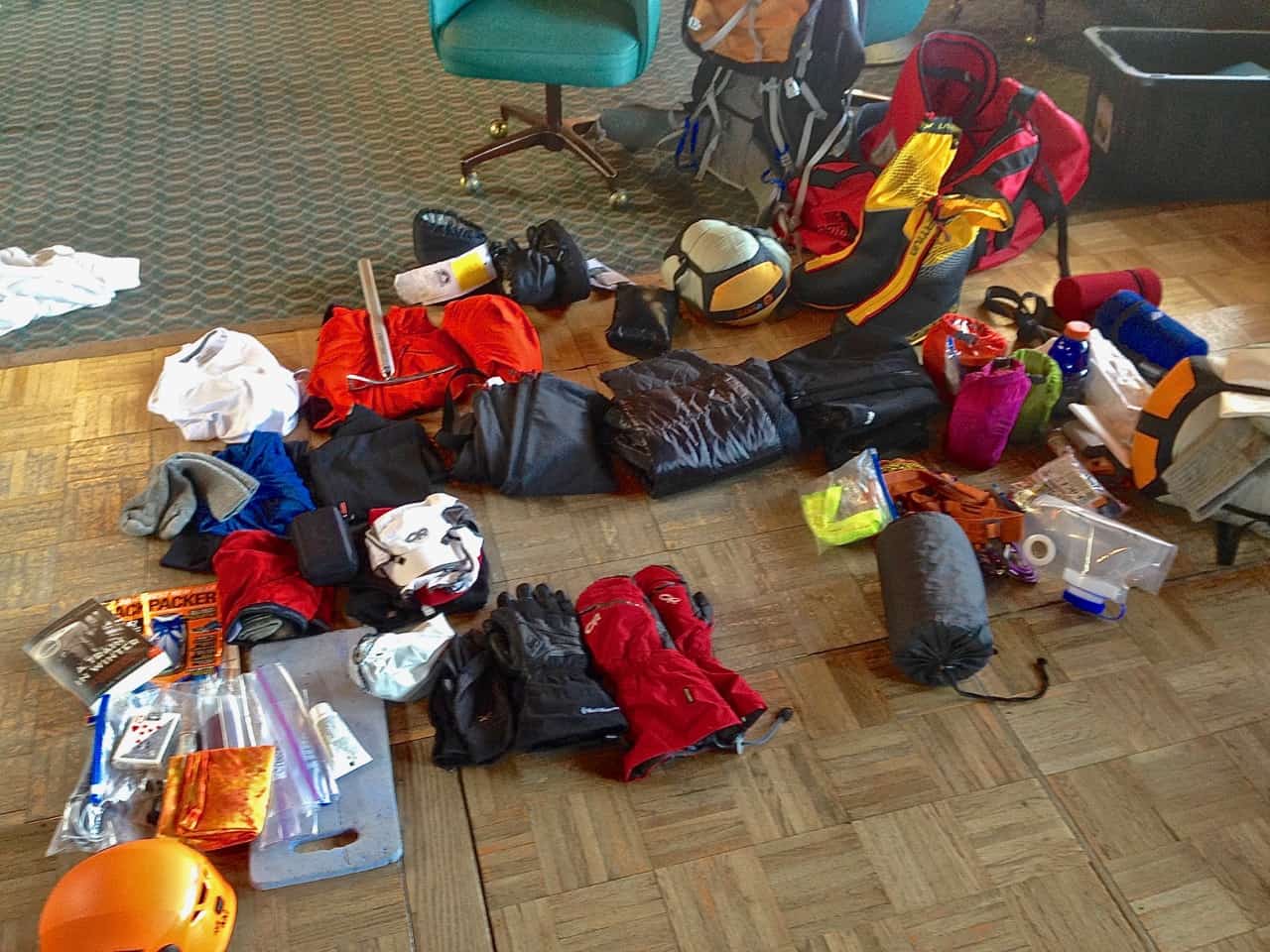

These pictures below show most of our gear laid out in the hanger before loading on the planes. The second picture shows all the gear including backpacks and duffel bags. All the white bags on the right are food bags for each day. Each bag has breakfast, lunch, dinner & snacks for one day. Seven of us have to carry all this gear for the next 2-3 weeks.
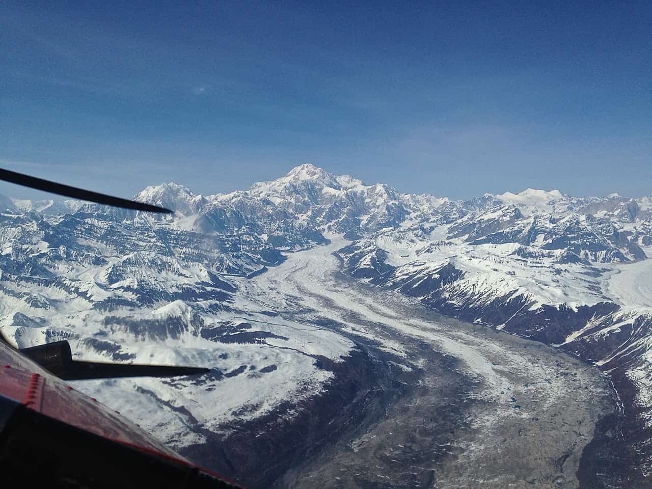
When we flew onto the glacier, I was lucky and guessed the correct number so I got to sit in the co-pilot seat. The views we fantastic from the front seat!
When we flew onto the glacier, I was lucky and guessed the correct number so I got to sit in the co-pilot seat. The views we fantastic from the front seat!


May 12th, we broke base camp down and took everything to Camp 1 which took us a few hours. Down 600+ feet out of Base Camp and then uphill until we hit Camp 1 at 7,800 feet. Once there, we set up the tents, dug the latrine pit, built snow walls and settled in. The small snow walls behind the tent are for the restroom. As you will see in later pictures, the snow wall Mikkel and I built is pretty pitiful but we had fun doing it! Picture taken by Selina.


May 13: Had a great night of sleep. The 8:00pm weather report said snow and cold was in the forecast for mid-day today so the guides decided we would stay put at Camp 1. We were up around 8:30am with breakfast at 9:00am. Temps were nice in the 20’s with slight breezes most of the day – some clouds, some sun. French toast for breakfast and PB&J sandwiches for lunch. Tomorrow with be a long day as we will carry a lot of gear to cache at around 10,000+ feet and return to Camp 1 for another night. Climbing up and then descending the same day helps with acclimatization to the altitude. We built some small snow walls for the tents in the afternoon. Took a nap and relaxed most of the day. Had Cous-Cous for dinner.
May 14: 7:00am breakfast. 8:35am started hiking. It was a cold breezy morning. Maybe in the 20’s. Higher up as we hiked the sun came out and it was calmer. The goal today was to bring a lot of gear to 10,000 feet and cache it for retrieval later. We made good time and the weather was nice so the guides decide to push a little higher to around 10,600 feet where we cached food and gear. This is just below Camp 2 which is at 11,200 feet. It took about 5 hours to get up and a 2 hour hike back down to Camp 1 at 7,800 feet. It was very, very warm coming down and a fantastic afternoon to be out. We relaxed until dinner around 6:30pm. Thai Peanut Noodles – excellent. We also planned out the next day. Approximately 7.5 miles round-trip and 2,800 feet of elevation gained and lost.


May 15: 6:30am breakfast of oatmeal and pop tarts. Broke camp and packed for a 8:35am start. Sunny for a couple hours and then clouds came in. Hot at times and then cool. Not much wind. Reached Camp 2 at 11,200 feet around 2:15pm and spent the next 2.5 – 3 hours setting up camp. I felt better this day and than I did yesterday. Lots of people at this camp compared to Camp 1. Roughly 4 miles and 3,400 feet of elevation gain.
The view looking over our tents towards the rest of Camp 2 and Motorcycle Hill in the distance. Motorcycle Hill is the snowy part and not the rock peak. You can just make out the trail which reaches the saddle where you then take a right hand turn and go up Squirrel Hill and end up on the Polo Fields before heading up to Windy Corner.


May 16: 8:00am pancakes and bacon for breakfast. Later in the morning we went down to 10,600 feet and got our cached items. It was a 10 minute hike down and an hour back up. We worked on the camp and bathroom area for a while and had grilled PB&J on pita bread for lunch. The afternoon turned sunny and breezy and it was very warm in the tent. I hung out in my long underwear on my sleeping pad mostly as we had 4-5 hours to relax before pesto pasta for dinner with custard for desert. Tomorrow will be a long tough day as we will climb to cache food and gear at around 13,600 feet and return to Camp 2.
May 17: 7:00am breakfast of granola and pop tarts. Started climbing around 8:30am. Finally switched from snowshoes to crampons. We climbed to 13,600 feet to cache gear and food and returned to Camp 2 for the night. 4.5 miles roundtrip and 2,400 feet elevation gain and loss. The girls used the sleds but all the guys just used backpacks. With all the food and gear they were very heavy and the climbs up Motorcycle Hill and Windy Corner were much steeper than anything we had attempted yet. It was approximately 4+ hours up and 1 hour 20 minutes down. This was the toughest day yet due to steepness and a heavy pack. I had many thoughts of “Why do I do this to myself!!” I also seriously thought about talking to the guides and telling them I was not sure I could do this again. However, in retrospect, every day we went to a new altitude, I struggled, or at least felt I was struggling and the next day when we did a section again, I was always stronger and better off. Essentially, I think this was part of the acclimatization process
May 17: 7:00am breakfast of granola and pop tarts. Started climbing around 8:30am. Finally switched from snowshoes to crampons. We climbed to 13,600 feet to cache gear and food and returned to Camp 2 for the night. 4.5 miles roundtrip and 2,400 feet elevation gain and loss. The girls used the sleds but all the guys just used backpacks. With all the food and gear they were very heavy and the climbs up Motorcycle Hill and Windy Corner were much steeper than anything we had attempted yet. It was approximately 4+ hours up and 1 hour 20 minutes down. This was the toughest day yet due to steepness and a heavy pack. I had many thoughts of “Why do I do this to myself!!” I also seriously thought about talking to the guides and telling them I was not sure I could do this again. However, in retrospect, every day we went to a new altitude, I struggled, or at least felt I was struggling and the next day when we did a section again, I was always stronger and better off. Essentially, I think this was part of the acclimatization process
The temps were cool and perfect for climbing as the snow did not soften up much until we headed down. The last 40 minutes down were very warm and we got back to Camp 2 around 1:45pm. It was a relaxing afternoon in the tent drying gear and resting. The sun was very warm until I was about to leave the net around 5:45pm. Clouds came in and it started snowing. Dinner was burritos. I am not looking forward to tomorrow as we will be breaking camp (a 2-3 hour process) and re-climbing everything we did today to take all the food/gear to Camp 3 at 14,200 feet where we have to spend 2-3 hours setting up a new camp. 6-8 inches of snow is predicted for tonight.
The only other issue during the day was I fell into two crevasses. Luckily they were small crevasses and in both cases, my left leg broke through and I went in to my thigh. The first was near the top third of Motorcycle Hill and the second was going around Windy Corner. They were very minor falls into very small crevasses and it only took a minute or so to get out and moving on. However, it did highlight the danger of crevasses in a more personal way…
This is a photo from the top of Motorcycle Hill looking up Squirrel Hill. Further up by the rocks it is a lot steeper than it looks in the photo. If you follow the rocks in the middle to the farthest left and lowest point, you can see another climber. At the top behind the middle rocks it flattens out somewhat into the Polo Fields. Photo by Selina.


May 18: 7:00am granola for breakfast. Broke camp and packed sleds and backpacks. Started climbing around 9:15am. Cool temps for 1-2 hours until we got high enough for the sun to hit us. I did much, much better than yesterday. We climbed for about 5.5 hours to Camp 3 at 14,200 feet. 2.75 miles and 3,000 feet of elevation gain. Sunny day with slight breezes. We took about 3 hours to set up camp and we started building some snow walls to protect the tents from the wind.
May 19: The night was very cold and I had to put on more gear to sleep comfortably. Mikkel looked at his temperature gauge in the morning and it was -30 degrees Centigrade which converts to -22 degrees Fahrenheit! We had breakfast at 9:30am…bacon and home fries which was excellent. The wind was blowing pretty good and we started building more snow walls right after breakfast for about 2 hours. The wind was very unpredictable and we estimated gusts at 40-50 MPH. At one point, the wind knocked over the small snow wall we built the day before. We finally stopped because of the wind and had a lunch break for 30 minutes. We then worked another 3+ hours building snow walls around the whole camp. Because the weather was bad we did not drop down and pick up our cached items at 13,600 feet. We decided to do that tomorrow. The sun came out later in the afternoon and the winds died down so late in the day was pretty nice.


May 20: A very cold night again. Around 10 degrees below zero. Slept in and had a late breakfast around 9:30am so the sun could hit the camp and warm us up. Late in the morning we hiked down to 13,600 feet to retrieve our cache from a couple days before. 30 minutes down and 1 hour 20 minutes back up. 1 mile roundtrip and 600 feet of elevation loss and gain. It was a fantastic sunny day. In the afternoon we practiced fixed line travel and took it easy the rest of the day.
Below are views of the climb we will have tomorrow to 16,200 feet to cache some food for a possible summit attempt in the next few days.
You will notice a trail and a bunch of people that look like ants heading up. Near the top, you should notice a very steep section of blue ice by the rocks. This is where the fixed lines are located which protect about 800+ vertical feet of the slope. I knew there were fixed lines from what I had read about Denali and I was looking forward to them, but, what I did not notice was the 2+ hour straight up climb just to get to the fixed lines! I was not looking forward to this climb. For those who live near me and know Mt. Washington, the fixed line portion is very similar to Tuckerman’s Ravine on Mount Washington, NH except it is all solid ice instead of corn snow. The Fixed lines and Tuckerman’s Ravine are both around a 50-55 degree climb.


May 21: A cold morning of minus 1 degree F. Raisin Bran with warm milk for breakfast. Packed up 2 days of food to cache at 16,200 feet. I have been dreading this day because the climb is steep and long. 3 hours 15 minutes up but we had very light packs and not many other people on the fixed lines. The fixed lines up and down were not fun at all. Approximately a 55 degree slope and solid ice that had been tramped on by hundreds of crampons. Very painful although it was also my first time at this altitude.
At the top there was no real flat area – the guides tied us into anchors to take a break while they dug a cache for our summit food. If you slipped and fell you would fall for a few thousand feet to almost assured death. Hmmmm, maybe I should have scheduled more beach time this summer… After a short break we went down the fixed lines which was not fun either. I kept thinking all day, how am I supposed to do this with a fully loaded 50+ pound pack?! Arriving back at 14,200 foot camp 3 most of us just laid down and relaxed for a couple hours.
In the picure below of Mikkel and Selina starting down the fixed lines - if you look just above Mikkel’s red backpack, you can see the concentration of tents at Camp 3 (14,200 feet). To the left of the main camp is the ranger campsite. Photo by Amy.
In the picure below of Mikkel and Selina starting down the fixed lines - if you look just above Mikkel’s red backpack, you can see the concentration of tents at Camp 3 (14,200 feet). To the left of the main camp is the ranger campsite. Photo by Amy.


May 22: Another cool morning but not excessively cold. We spent a few hours building snow walls around the campsite. I finished a book in the afternoon. We had freeze-dried dinners and off to bed. Temps to -5 degrees F and wind gusts to 25 MPH predicted for the night. Adam and Mikkel built a stick figure out of snow and Amy decided to look hot next to it. We also walked to the ranger station and the other campsites to check them out. A pretty relaxing day overall. Most of the trip we played a lot of UNO and another card game that Mikkel taught us from Norway. I can’t remember the name of it since it was in Norwegian!


May 23: We are stuck at 14,000 feet due to bad weather on the summit. Added one layer of snow walls to the camp. We all built a replica of Big Ben since Selina is from Britian. Walked to the Ranger Station again to check the weather board. Slept bad last night. Felt like I could not get any oxygen and had trouble concentrating. Temps were -5 F and winds to 25 MPH. Most of the day was sunny and nice though. Andrew built a pit to do a pull-up contest in which should be interesting tomorrow. Tonight is supposed to be -5F and windy again. Weather predictions for the next few days are not good. 1-2 feet of snow and 50MPH winds predicted for the Sunday.


May 24: Up late for a nice sausage and home fries breakfast. Because weather forecast is bad, we climbed back up to 16,200 feet to retrieve our summit food cache. I was dreading this climb. It was steep the whole way and then you have the fixed lines for the last 800+ feet. However, I did do better than the first time up this altitude a few days ago. It was a fairly long day. My left leg was sore from hyperextending it the last time we came down from 16,200’. The 8:00pm weather report was not good for the rest of the week. Still 1-2’ of snow predicted with 50 MPH winds sunday and possibly more snow Tue/Wed. Summit temps and winds were too cold and too fast to move up.

May 25: The weather predictions were for 1-2 feet of snow but we woke up to just a couple inches. Up late for breakfast again and took a walk to the ranger station to check the weather. It is not looking good for summit attempts. As the guides explained, we need a minimum of 3 days and preferably 4 days for a summit attempt. One day to go from 14,200 feet at Camp 3 to 17,000 feet at Camp 4, one day to rest and help acclimatize, one day to summit and get back to 17,000 feet and a fourth day to get from 17.000 feet back to 14,200 feet. Four days is optimal but a summit bid is possible with only 3 days except you lose a day to acclimatize which can affect people differently. In addition, the temperatures and wind speeds need to be reasonable. Something like zero degrees and 20 MPH winds or possibly -20 degrees with minimal wind – either of these would be on the edge or reasonable. Pretty much anything better than those combinations would allow a summit attempt.
We played UNO and a Norwegian card game which was fun. Read a book and napped too. Outlook for the summit this week is not good. We will see what tomorrow brings.
May 26: Up late again since we are not moving anywhere today and it gives the sun time to come up and hit our camp. Read a book for a while and then we all walked over to the “Edge of the World” to take some photos and explore. Played more UNO and then walked over to the AAI Team 3 that was a week behind us. I saw Paul and Nancy who did the Denali Prep course with me on Mt. Baker in WA back in Feb/Mar timeframe. During dinner, we had discussions on the weather and plans to move up to 17,000 feet tomorrow depending on the weather when we get up. Things are looking promising!


View of Camp 3 at 14,200 feet coming back from the Edge of the World. Those tiny little bumps on the horizon are tents and people. Photo by Mark

May 27: Today is the day that we are hoping to climb to 17,000 feet. However, when we got up, the guides had some bad news. The weather forecast for the next few days had completely changed with predictions for lots of snow all over the mountain. So, after a breakfast at 7:00am our hopes were dashed and our window for a summit attempt had closed. Because there is no chance to summit and the weather is looking bad, the decision is made to break camp and go all the way down to base camp today. We spent 2-3 hours breaking camp and packing up ALL the gear.
We started down late morning and arrived at Base Camp around 9:00pm after a 10+ hours slog through snowy conditions with lots of wind around windy corner and the polo fields. Once we hit Camp 2 and retrieved our cache, the rest of the way down to base camp was not too windy but it did snow steadily. Total distance was approx 12.25 miles. We go from Camp 3 at 14,200 feet down to 7,200 feet and then go the last half-mile up Heartbreak Hill and gain 600 feet. Total elevation loss and gain is around 7,800 feet.
We started down late morning and arrived at Base Camp around 9:00pm after a 10+ hours slog through snowy conditions with lots of wind around windy corner and the polo fields. Once we hit Camp 2 and retrieved our cache, the rest of the way down to base camp was not too windy but it did snow steadily. Total distance was approx 12.25 miles. We go from Camp 3 at 14,200 feet down to 7,200 feet and then go the last half-mile up Heartbreak Hill and gain 600 feet. Total elevation loss and gain is around 7,800 feet.
We spent a couple hours setting up camp and eating before hitting the sack for the night. We were all looking forward to hopefully flying out the next morning.


May 28 – May 31: OK, the weather never cleared overnight. In fact, we are socked in by clouds and snow for the next 4 straight days. A bunch of people stream into camp each day from higher on the mountain looking to get out but no planes are flying. It turned out to be a few days of boredom…mostly reading books, watching movies, eating, and walking on the runway with snowshoes a few times to tamp down all the new snow for a landing strip. I think we all find it a bit frustrating because once we realized we would not summit, we kind of wanted to be off the mountain and move on to other things.


June 1: Sunny weather! Finally, the weather is breaking and the whole camp is getting excited to leave.


The first picture below is the very first day on the glacier. If you notice the white tent in the background, you can compare it to the next picture which is the last day of the trip. We received a lot of snow in 3 weeks although I think most of it was the last 4-5 days while we were stuck there.


